
CapitalNYBikeMap - Help Page
Designed and maintained by Albany Bicycle Coalition
Questions & comments, email to: albanybicyclecoalition@yahoo.com
Revised map interface - effective December 22, 2025
The "dashboard" formerly at the top of our map has been discontinued by the manufacturer (ArcGIS).
Therefore, all map tools (Legend, Layers, Measure, etc.) have moved from the top rectangle, to the corners of the screen.
A detailed description of the new interface can be found below.
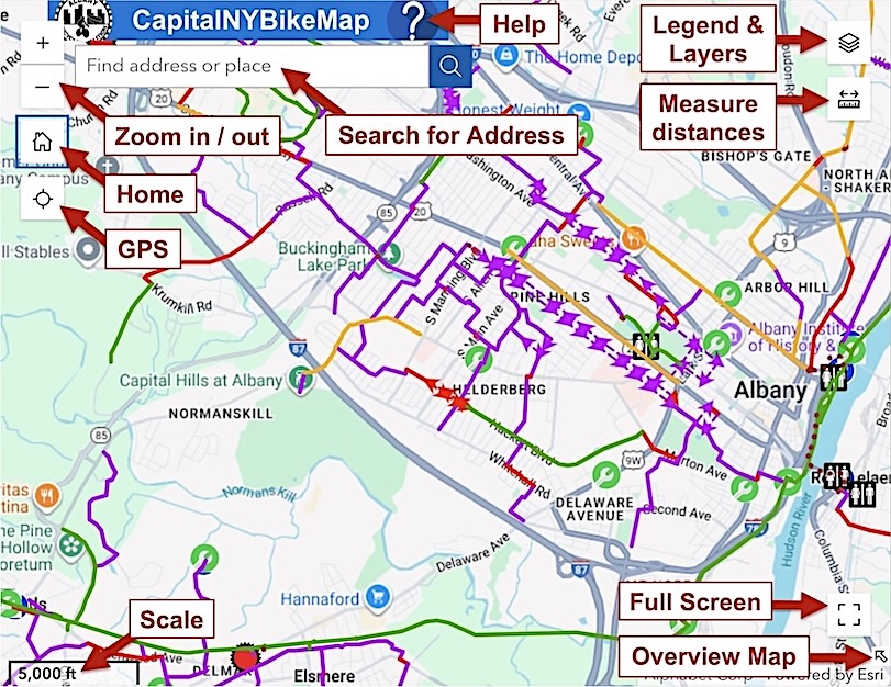
This quick-reference guide shows how to quickly find all functions. On a smart phone, some icons may be in different corners.
(To open a full-page printable PDF in a separate tab, click the graphic.)
Go directly to the revised map
NOTE: if you bookmarked the original map, you will need to replace it with the new link. As always, the best way to access the map is via
the CapitalNYBikeMap.com home page, to make sure that you see all current alerts and updates.
Safety Notice and Disclaimer
This map seeks to provide suitable low-stress routes for adult cyclists of average ability. It attempts to avoid heavy traffic, and highlights bike infrastructure where it exists. However, sharing the road with motor vehicles always has inherent risks.
• Ride defensively; be predictable; obey traffic laws!
• Routes marked "Heavy Traffic" (in red) should be ridden with special caution, and only by experienced adults.
• Click the triangular Caution icons  for pop-up safety advice.
• Even multi-use paths have safety challenges - vehicle intersections, pedestrians, winter ice, degraded surfaces.
• Conditions may vary due to construction, weather, or other factors.
Ultimately, cyclists must be responsible for their own safety.
Quick Reference
- Tools (legend, layers, etc.) are accessed via icons located at the corners of the window.
- Location of these icons will vary; smart phones may differ from desktops and laptops.
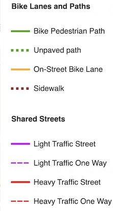
- Routes are color coded (refer to Legend).
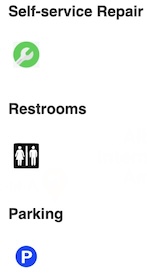
- Seven icons within the map will display pop-up information when clicked; refer to Legend for descriptions.
- Three icons (Caution, Directions, Bike Share Hubs) are displayed only when zoomed into street level, to avoid overcrowding your screen.
- Google Maps points of interest are visible - but are not clickable.
- Turn features off and on using Layers.
- Satellite map, Terrain map, and Building & Street Detail can be enabled from Layers.
- Click the GPS-circle-icon at upper left, below the + / - signs, to display your location as a blue circle on your smart phone or tablet.
To turn off GPS, double-click the icon (or refresh your browser window).
- Search for addresses or businesses by typing inside the box at upper left.
When the correct item appears, click it; the map will zoom to that location.
- The large ? at the top links back to this Help page.
- The round logo at upper-left will open the Albany Bicycle Coalition home page in a separate tab.
- Overview map shows your current map display within a regional map.
You can reposition your map by dragging the small shaded rectangle.
Upper-left-corner icons
 Click + to zoom in.
Click - to zoom out.
(or, use your mouse wheel to zoom in/out).
Click the house icon to reposition entire map to initial location.
Click the circle to turn on GPS; a blue circle will appear.
To turn off GPS, double-click it (or refresh your browser, Ctrl-R or Command-R)

Click the circular logo to open albanybicyclecoalition.com website in a new tab.

Click the large ? to open this Help page in a new tab.
Search for address or site
 Type an address, or the name of a business or building,
in the box left of the magnifying glass.
A list of possible choices will drop down;
click on the address that you want.
The map will relocate to that location.
Map Tools: Legend, Layers, Measure, etc.
Tools are accessed via icons in the corners of the window.
You can view a Quick Reference Guide to all tools
in a separate tab (one-page printer-friendly PDF file).
Layers
 The "Layers" icon accesses the Layers and the map Legend.

Two tabs will pop up; switch between Layers and Legend by clicking a tab at the top.
To toggle a layer on/off, click anywhere within its rectangle.
The tiny "eye" symbol, with a line through it

indicates a layer is turned off.
To turn on alternative maps, scroll down to the bottom of the list.
• "Building & Street Detail" displays individual buildings, and enhanced street names in medium zoom.
It can also be used in combination with "Terrain" or "Satellite."
• "Satellite" shows highly-detailed overhead images; it hides Terrain features,
but is compatible with street display.
• "Terrain" shows major topographical elevations superimposed on the street maps.
Legend
Only items currently turned-on and visible will be shown in the Legend.
Routes are color-coded, as follows:
To view icons, keep scrolling down.
• Icons display pop-up information when clicked within the map.
• Caution icons display ongoing hazardous conditions; they are not updated in real time.
• Caution, Directions, and Bike Share Hubs are displayed only when zoomed into street level, to avoid overcrowding your screen.

Measure

To measure distances, click the ruler icon in the corner.
(Usually, top-right corner; may be different on small screens.)

A menu pops up; follow the instructions;
click any spot to begin.
Click a spot to begin measuring.
As you move the mouse, a dotted line appears . . .
Click at a second spot, and a line is drawn automtically.
Click at a third spot if necessary, and so on;
At the final destination, double click to finish measuring.
The total distance is displayed under "Distance."
If the units is wrong, use the "Unit" drop-down (red arrow) to change it;
e.g., "Imperial" = miles/feet, and "Metric" = kilometers etc.

To do a new measurement, click the New measurement button, and repeat the process.
(The right icon is for area measurement. Although not as relevant to cyclists, the principles are similar to distance measurement.)
When finished, click the X to close the Measurement window.
Full Screen
 Fills entire screen.
(Other browser tabs typically aren't visible.)
Click it again, or press Esc, to undo.
Overview Map
 Very-small icon in lower-right corner.
(Might not be implemented on smart phones and tablets.)
The Overview Map is an alternate method for quickly navigating to other locations.
An inset map will pop up in the lower-right corner.
The shaded rectangle is the locality currently displayed.
Drag the rectangle, to reposition the main map.
When done, click the icon again to turn off.
For further adjustments, use your mouse to drag the map, as usual.

Questions? Comments? Suggestions for new routes?
Please email us at: albanybicyclecoalition@yahoo.com
and include "Bike map" in your subject line.
Return to CapitalNYBikeMap.com home page